


Reportage
On shaky ground

An Independent Newsweekly


Reportage
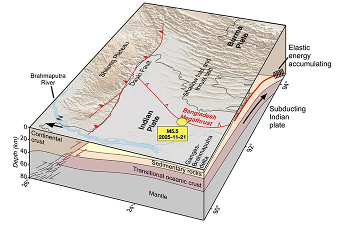
The quake, and subsequent aftershocks, occurred near the junction of the Indian and Burmese plates. (USGS)
The morning of November 21, 2025 - a Friday - is one that most Bangladeshis, but especially residents of Dhaka city, will likely remember for the rest of their lives. For years, despite various institutions, experts or even ordinary residents periodically voicing their concern over how the capital might cope in the event of a significant earthquake, the city's teeming masses - projected at a whopping 36.6 million by the UN this week - could be said to have lived a charmed life till now.
That's because despite several warnings, the big one never came. And eventually, we started believing it never would. Over a period covering at least three full decades, earthquakes felt in Dhaka happened to be distinctly mild, resulting in no casualties despite several occurrences. Yet in the last few years, there has been an increase in the frequency of earthquakes occurring close to Dhaka - i.e. with their epicentres often within Bangladesh. Starting from February 2021, the Bangladesh Meteorological Department recorded 39 earthquakes that had their epicentres within Bangladesh. Eleven of those originated within 100 kilometres of the capital - but none came close to last Friday's.
At 10.38am, the entire sleepy capital, where most residents would've been feeling the first pangs of winter on a holiday, was violently shaken out of its slumber. Showpieces, pots and pans, jars on tables fell over. TVs swayed uncontrollably from side to side. Some buildings even tilted. It was all over in under a minute. But that's often all it takes.
Having registered that an earthquake was taking place, after the initial shock presented by the unprecedented shaking, panicked residents rushed out of their homes, or sought to at least. Many got in each other's way and this resulted in a number of injuries. At Dhaka University, some of the halls' resident students even jumped from their floors, damaging their limbs in the process.
It was soon revealed that the epicentre of the earthquake was in Madhabdi upazila of Narsingdi, 25 kilometres from Dhaka's Zero Point, but just 13 kilometres from the BMP's earthquake sensors in Agargaon. The earthquake affected mostly central Bangladesh.
Due to the earthquake, walls collapsed in various places. Railings and parts of some buildings were seen falling off. Many people fell sick out of fear (and are still under that spell!).
At least 10 people died across three districts - one person died in Narayanganj, four in Dhaka, and the highest five in Narsingdi. More than 600 people were injured.
According to BMD, the earthquake originated, Friday, November 21 at 10:38:26 AM in Madhabdi upazila of Narsingdi. Its magnitude on the Richter scale was 5.7. However, the United States Geological Survey (USGS) measured the magnitude at 5.5. It occurred at a depth of 10 kilometres below the surface, and lasted 26 seconds.
In a later update, USGS said the November 21, 2025, M 5.5 central Bangladesh earthquake occurred as the result of "reverse faulting" at a shallow depth within the Indian plate. It adds that: "Focal mechanism solutions indicate rupture occurred on either a moderately dipping fault striking east or a moderately dipping fault striking west-northwest."
Earthquakes occur on faults. In an earthquake, the rock on one side of the fault slips with respect to the other. The fault surface can be vertical, horizontal, or at some angle to the surface of the earth. The slip direction can also be at any angle. Earth scientists use the angle of the fault with respect to the surface (known as the dip) and the direction of slip along the fault to classify faults.
Reverse faulting is a type of dip-slip fault where the block above the fault plane (the hanging wall) is pushed up and over the block below (the footwall) due to compressional stress in the Earth's crust. This process is often associated with convergent plate boundaries, where one tectonic plate is colliding with another. However USGS in this case has assessed that the November 21 quake in Narsingdi occurred within the Indian plate.
A focal mechanism solution is a graphical representation of an earthquake's faulting type and orientation, created by analyzing seismic waves to determine the type of rock failure that occurred. It provides key information about the earthquake, including the fault's geometry, the direction and sense of slip.
All eyes on Narsingdi
At the epicentre in Narsingdi's Madhabdi, the tallest structure - J and J Tower, a 14-storey building housing a hospital and apartments - shook violently, and swayed 'like trees' witnesses said. Many residents of Narsingdi described their experiences on Facebook. Several posted photos of cracked walls and floors. Others shared images of furniture strewn across their homes.
By evening, five earthquake-related deaths were reported across the district.
In Sadar upazila's Gabtali area, construction materials from a nearby multi-storey building collapsed onto a one-storey house, causing the roof to cave in on a father and son. The son, Md Omar Faruk (9), died on the way to Dhaka; the father, Md Delwar Hossain (37), died later at Dhaka Medical College Hospital. Their deaths were confirmed by Delwar's brother Zakir Hossain.
In Malita village of Palash's Charsindur Union, 75-year-old Kajom Ali Bhuiyan died when the wall of a mud house collapsed. He was inside with two grandchildren.
In Kaziarchar's Nayapara area of Danga Union, Nasir Uddin (65) died after suffering a stroke during the quake while speaking with family members inside the house.
In Ajkitla village of Joynagar Union in Shibpur, Forqan Mia (35) fell from a tree due to the tremors and later died at Narsingdi Sadar Hospital, confirmed by Shibpur police station OC Afzal Hossain.
The quake also caused ground ruptures in at least two places in Palash. One appeared on the dirt road leading to Palash Residential Model School and College. Director Arif Pathan said the severe shaking caused the cracks to open during the morning tremor.
Another set of long cracks appeared at Ghorashal Dairy Farm in the Lebupara area, stretching across the courtyard. Workers said the fissures formed at the height of the shaking.
Zone of Activity
It is rare for earthquakes in Bangladesh to result in multiple fatalities. The last time it happened was in 1999, when an intense earthquake shook the island of Moheskhali, killing 6 people. Hundreds were also injured on the island off the coast of Chattogram in the country's south-east.
But Friday's quake was instantly recognisable as something different, with deeper repercussions. Besides the casualties being spread across three districts, the epicentre being so close to Dhaka caused a projected 10 million people in Dhaka to feel 'strong shaking', according to the United States Geological Survey, which is the leading authority on earthquake data worldwide.
Closer to the epicentre in Narsingdi, about 300,000 people were projected to have felt 'high-intensity' shaking. Literally everyone we spoke to in the capital confirmed they had never felt the ground shaking like it did during Friday's quake.
It was followed almost exactly 24 hours later by a much smaller aftershock, again with its epicentre in Narsingdi's Palash upazila. The BMD reported that this quake, measuring 3.3 on the Richter scale, occurred at 10:36am on Saturday, about 29 km west of the BMD Seismic Centre in Agargaon.
And then on Saturday evening, a third tremor in the space of 32 hours, considered a second aftershock of Friday's quake, was felt in parts of Narsingdi and nearby districts including Dhaka. According to USGS, this one measured 4.3 on the Richter scale and struck at 6:06pm local time, with its epicentre located 11 kilometres west of Narsingdi at a depth of 10 kilometres.
Almost six days later, another aftershock was recorded at 4.15pm on Thursday, November 27. Its magnitude was recorded as 3.6 on the Richter scale by BMD, but USGS put it at 4.0. The epicentre was recorded by BMD at Madhabdi in Narsingdi, hence its classification as an aftershock. The depth was again 10km below the surface.
Even though no casualties were reported from either of the two aftershocks, they served to heighten anxiety, confirming that the fault lines lying deep beneath them in the earth's crust had become seismologically active.
Several buildings across various areas of Dhaka were damaged after Friday's earthquake. According to the Dhaka district administration, at least 14 buildings in the capital sustained damage from the quake, while the Rajdhani Unnayan Kartripakkha (Rajuk) put the number at over 50, including many that had tilted. These have now been instructed to undergo Detailed Engineering Assessments (DEAs) within 15 days.
Additionally, RAJUK identified some 300 buildings, including both large and small ones, as 'high risk', and in need of immediate attention.
For survivors, the psychological impact lingers. For many, the ground no longer feels stable, and the fear of a stronger quake currently haunts millions across Dhaka.
"I am a student of Mujib Hall (2024-2025 session). I became traumatised because of the earthquake. I live in the July Smriti Bhaban of Mujib Hall. Now, whenever a vehicle passes by my building or I hear even the slightest sound, I panic," a Dhaka University student shared.
"It feels as if another earthquake is happening. I repeatedly check my room and surroundings to see if there is a tremor," he added.
At least four students were seriously injured after jumping from the residential hall buildings of Dhaka University in panic during Friday's quake. The university ended up first cancelling all classes scheduled for Sunday, before a syndicate meeting on Saturday suspended all academic activities till December 6, citing the physical and mental stress caused by the earthquake and its aftershocks, as well as the need to renovate the residential halls.
Risky Buildings in Dhaka
According to RAJUK, the first list of risky buildings was prepared in 2010 and updated in 2016. Currently, Dhaka has 321 extremely risky buildings, mostly in Old Dhaka. In 2024, RAJUK also identified 30 risky buildings across 21 educational institutions.
A RAJUK survey conducted under the Urban Resilience Project between 2018 and 2022 found that approximately 865,000 buildings in Dhaka could collapse if a 6.9-magnitude earthquake struck the Madhupur Fault near Tangail. Such a scenario could result in 210,000 deaths and 229,000 injuries if it occurred during daytime hours.
Bangladesh's cities, including Dhaka and Chattogram, remain highly vulnerable to earthquakes due to widespread disregard for building codes, master plans, and land-use zoning, according to the Institute for Planning and Development (IPD).
Adil Muhammad Khan, Professor at the Department of Urban and Regional Planning at Jahangirnagar University, emphasised the urgent need for preparedness, citing the recent 7.7-magnitude earthquake in Myanmar as a stark reminder of the risks.
Experts have also expressed concern that, despite the formation of multiple reform commissions, the interim government has yet to establish a dedicated authority for planned urbanisation, sustainable housing, and building safety.
The Bangladesh Institute of Planners criticised the formation of an advisory council allegedly influenced by real estate developers to amend Dhaka's Detailed Area Plan (DAP), favouring unrestricted high-rise construction.
A new paradigm in construction?
When a 9.1-magnitude earthquake struck Japan in 2011, in buildings equipped with an innovation known as 'base isolation', not even a glass fell from the shelves.
It is a construction technique in which the building (or other such establishment)is not rigidly attached to the ground. Instead, hundreds of special rubber-lead bearings are installed beneath it. When an earthquake hits, the ground may shake violently, but the building above moves gently - swaying slowly rather than shaking hard. As a result, people, furniture, equipment, and interior structures remain almost completely unaffected.
Today in Japan, nearly all new towers, buildings, hospitals, schools, and data centres are required to have this system. Even 40-50-year-old buildings are being retrofitted by cutting the foundation and installing base isolation to give them a new, safer life.
Some engineers recommend that Bangladesh should move in this direction to save itself from a catastrophic situation in the future.
Under the Bangladesh National Building Code-2020 (BNBC-2020), important structures in Dhaka and Chattogram have already started using base-isolation systems. The Rooppur Nuclear Power Plant, several metro rail stations, and a few new towers are already implementing this technology.
A paper titled "Status of Base Isolation Applications in Bangladesh" was presented at the 19th World Conference on Seismic Isolation, Energy Dissipation and Active Vibration Control of Structure at Berkeley, USA in September this year.
Tahmeed Al-Hussaini from Bangladesh University of Engineering and Technology and Khondaker Sakil Ahmed from the Military Institute of Science and Technology described the significance of the use of this technology.
They mentioned that Bangladesh, located near the plate boundaries of Indian and Eurasian plates to its north and east, possesses significant seismic risk. Seismic Zone V of India, assigned with the highest seismic risk in that country, encircles Bangladesh on its northern and eastern sides.
Their paper also referred to the fact that base-isolation has been adopted in two major bridges of Bangladesh. The 4.8-km Jamuna Bridge contains seismic steel pintles for earthquake protection, while the 6.1-km Padma Bridge contains double concave friction pendulum bearings.
Analysis shows satisfactory performance of both base isolation systems. Particularly for Padma Bridge, the seismic demand on the bridge was large due to very deep pile foundations, double deck heavy superstructure and deep scour in the Padma River.
Research results show that base isolation may be satisfactorily applied for mid-rise to high-rise buildings in Bangladesh.
And the first application of base isolation to a building in Bangladesh is planned for a new headquarters of the Fire Service and Civil Defense in Dhaka.
Considering earthquake risk, Bangladesh is divided into three seismic zones. Among them, the high-risk areas fall under Zone-1, medium-risk areas under Zone-2, and the least-risk areas under Zone-3. A map published by the Meteorological Department identifies the earthquake-prone regions of the country.
In particular, nine districts of the Sylhet and Mymensingh divisions; parts of Tangail, Gazipur, and Narsingdi in the Dhaka division; the entire Kishoreganj district; Brahmanbaria in the Cumilla division; and large areas of the hill districts Khagrachhari and Rangamati are identified as high-risk zones.
Statistics show that between 1976 and 2015, Bangladesh experienced at least five major earthquakes. Almost all of these originated in Sylhet, Moulvibazar, Rangamati, Bandarban, and Cox's Bazar. Historically, it has been expected that these areas may also experience stronger quakes in the future.
But the rapid and unplanned development of centrally located Dhaka city in the period since independence, and its proximity to the epicentre of the weekend's tremors, are triggering renewed concerns over the fate that awaits the capital's residents.
During the inspection at three affected areas of Dhaka on Saturday, the RAJUK Chairman Engineer Md Riazul Islam said this earthquake was a warning for us. "If we do not take it seriously, a major disaster awaits," he warned.
He added that authorities are preparing a list of the buildings that were damaged in the quake. The risky structures are being inspected on-site, and those found highly unsafe are being sealed or closed.
"In some cases, dangerous installations are being removed. Unless all of us become aware and act responsibly, we may face a severe catastrophe in the near future."
Environment adviser Syeda Rizwana Hasan has warned that nearly 90 per cent of old buildings in Dhaka were constructed without following the building codes, leaving the capital extremely vulnerable, especially in light of the recent earthquakes.
Another taskforce loading
In the wake of the earthquake, the interim government decided to form an expert-led task force and take immediate preparedness measures following a high-level emergency meeting on earthquake risks, where leading scientists and academics reaffirmed that there is no reason to panic but urged coordinated, science-based action.
The meeting was held on Monday (Nov. 24) and chaired by Chief Adviser Muhammad Yunus, who asked attending experts to submit written recommendations "as quickly as possible", saying the government would act immediately on their guidance.
"We do not want to fold our hands, nor take any unscientific steps," he said."Give us your suggestions in writing, and the government is ready to take all necessary steps."
He said the process is already underway to form one or more technical committees and a taskforce, which will begin work as soon as expert submissions are received.
The task force will include both government and private-sector specialists and will be responsible for rapid earthquake preparedness measures, including drills, public awareness, and building safety assessments.
The overall messaging from the IG has been: "Be prepared, without panicking".
A Independent Newsweekly
© Copyright 2026 | Designed by ARK Reepon & Developed by Cosmos Group Software Team


Leave a Comment
Recent Posts
Art, Love and Resistance: A Co ...
The exhibition Braids and Threads: Connecting Legacies by artists Mo ...
VTRT rescues 10-foot python fr ...
The Village Tiger Response Team (VTRT), trained and supported by WildT ...
The Hormuz Crisis and the Fate of the Global South
The Great Hungarian Reset
Dr Yanan Wu
The fate of the bhadralok